Tocht Mountainbike Le Crotoy - LP80_StFirmin-Le-Bout-des-Crocs_7.5Km - Photo

LP80_StFirmin-Le-Bout-des-Crocs_7.5Km

Autour de la Baie à pieds

© OpenStreetMap contributors
Lengte
Lengte
7,4 km
Max. hoogte
Max. hoogte
13 m
Positief hoogteverschil
33 m
Km-Effort
Km-Effort  
7,9 km
Min. hoogte
Min. hoogte
2 m
Negatief hoogteverschil
33 m
Boucle
Boucle
Ja
Datum van aanmaak :
2020-10-21 07:11:25.983
Laatste wijziging :
2023-10-03 19:10:11.009

(0 Bericht)

Mountainbike
Mountainbike
32m
Moeilijkheid : Gemakkelijk

Scan deze QR-code om de tocht te openen in de SityTrail-applicatie

Gratisgps-wandelapplicatie

Logo SityTrail SityTrail

IGN / Geografische instituten

SityTrail uit de App Store downloaden SityTrail uit Google Play downloaden

Logo SityTrail SityTrail World

De wereld gaat voor u open

SityTrail uit de App Store downloaden SityTrail uit Google Play downloaden SityTrail op Huawei AppGallery downloaden

Over ons

Tocht Mountainbike van 7,4 km beschikbaar op Hauts-de-France, Somme, Le Crotoy. Deze tocht wordt voorgesteld door BAIE de SOMME & alentours.

Beschrijving

Par les chemins

Hoogteprofiel

Plaatsbepaling

Land:
France
Regio :
Hauts-de-France
Departement/Provincie :
Somme
Gemeente :
Le Crotoy
Locatie:
Unknown
Vertrek:(UTM)
402048 ; 5568602 (31U) N.

Wandeltochten in de omgeving

Tocht Stappen Le Crotoy - CDT80-3 - Photo
Stappen

Stappen

Medium
(2)
Le Crotoy, Hauts-de-France, Somme, France
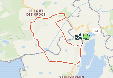
6 km | 6,1 km-effort
1h 23min
Ja
Tocht Stappen Saint-Quentin-en-Tourmont - Les crocs - Saint Quentin en Tourmont - Photo
Stappen
tracegps

Stappen

Moeilijk
(4)
Saint-Quentin-en-Tourmont, Hauts-de-France, Somme, France
15,8 km | 16,9 km-effort
5h 30min
Ja
Tocht Stappen Favières - Circuit de Morlay - Photo
Stappen
tracegps

Stappen

Moeilijk
(1)
Favières, Hauts-de-France, Somme, France
12,4 km | 12,8 km-effort
4h 0min
Ja
Tocht Fiets Rue - Rue-Ailly sur Somme par les chemins de Halage - Photo
Fiets
Baltykatt

Fiets

Medium
(2)
Rue, Hauts-de-France, Somme, France
75 km | 76 km-effort
4h 39min
Neen
Tocht Paard Le Crotoy - de la Maye vers marquenterre - Photo
Paard
ioudina

Paard

Heel gemakkelijk
(4)
Le Crotoy, Hauts-de-France, Somme, France
20 km | 21 km-effort
2h 43min
Neen
Tocht Fiets Le Crotoy - Crotoy - Marquenterre - Photo
Fiets
jacques.moulin@hotmail.com

Fiets

Medium
(1)
Le Crotoy, Hauts-de-France, Somme, France
18,3 km | 19,2 km-effort
1h 8min
Ja
Tocht Stappen Le Crotoy - traversée baie somme et train - Photo
Stappen
lefrancm

Stappen

Heel gemakkelijk
(1)
Le Crotoy, Hauts-de-France, Somme, France
24 km | 25 km-effort
6h 58min
Neen
Tocht Stappen Le Crotoy - La Maille - Pointe de St Quentin - Photo
Stappen
tbrunet

Stappen

Medium
Le Crotoy, Hauts-de-France, Somme, France
9 km | 9,1 km-effort
4h 30min
Ja
Tocht Te voet Le Crotoy - Balade au Crotoy - Photo
Te voet
GUIDE+

Te voet

Gemakkelijk
Le Crotoy, Hauts-de-France, Somme, France
9,9 km | 10,4 km-effort
2h 22min
Ja


Sluiten
Mijn abonnementen